publications
publications by categories in reversed chronological order. generated by jekyll-scholar.
2026
- SIGSPATIAL
 Sven Ligensa, Jan Pauls, Karsten Schroedter, and 2 more authors Ibrahim Fayad, Fabian Gieseke minimizeIn Proceedings of the 34th ACM International Conference on Advances in Geographic Information Systems (SIGSPATIAL), 2026
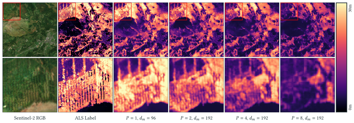
Predicting canopy height from medium-resolution satellite imagery is a common and scalable approach for assessing the condition of the world’s forests, which play a crucial role in climate change mitigation. While Transformer-based architectures have shown strong performance in many domains, their straightforward application to dense (i.e., pixel-level) regression tasks often yields suboptimal results. In particular, the patch size has a crucial impact on the model performance. In this work, we consider pixel-level attention schemes and show that the resulting models generally outperform those relying on larger patch sizes. However, pixel-level attention can be a prohibitively resource-intensive operation. For this reason, we conduct an extensive experimental study using efficient attention variants to identify favorable trade-offs between prediction quality and resource requirements, facilitating the practical deployment of the proposed models. In addition, we perform a comprehensive comparison with several well-established models in the field and show that, with suitable hyperparameter choices, Transformer-based architectures can outperform competing approaches. Our findings provide practical guidance for designing models for pixel-level regression tasks on medium-resolution satellite imagery, including canopy height and biomass estimation, soil moisture mapping, and yield forecasting.
@inproceedings{ligensa2026pixel, title = {Pixel-Level Transformers in Remote Sensing: A Canopy Height Case Study}, author = {Ligensa, Sven and Pauls, Jan and Schroedter, Karsten and Fayad, Ibrahim and Gieseke, Fabian}, booktitle = {Proceedings of the 34th ACM International Conference on Advances in Geographic Information Systems (SIGSPATIAL)}, year = {2026}, publisher = {ACM}, doi = {10.1145/3841645.3842978}, url = {https://arxiv.org/abs/2609.37809}, tags = {ml,application,rs}, } - RSE
 Alba Viana-Soto, Jorunn Anna Mense, Katja Kowalski, and 3 more authors Jan Pauls, Fabian Gieseke, Cornelius Senf minimizeRemote Sensing of Environment, 2026
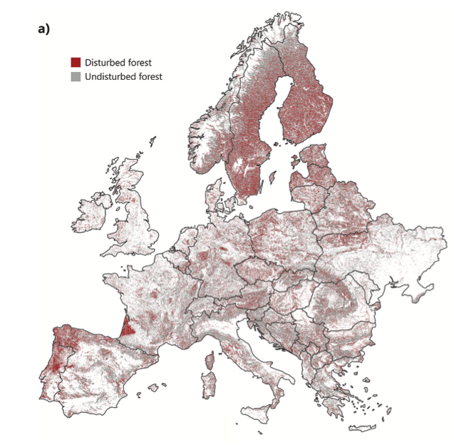
Forests in Europe are under growing pressure from climate extremes and land use intensification. Long-term monitoring is therefore required to understand disturbance dynamics, yet producing temporally and spatially consistent disturbance maps at continental scales remains challenging. Emerging deep learning models might improve upon existing models by learning spectral-temporal patterns relevant for disturbance detection directly from the underlying data, while simultaneously ignoring noise. Despite their promise, deep learning models have not yet been used for continental-scale disturbance mapping. Here, we implemented two temporal deep learning models (TempCNN and 1D U-Net) for annual forest disturbance detection across all forests of continental Europe using Landsat time series from 1985 to 2024. We evaluated the performance of both models for detecting forest disturbances using short temporal subsequences from the whole time series and compared them to existing approaches based on Random Forest. The 1D U-Net outperformed the TempCNN and Random Forest models across variable classification scenarios. The highest performance was achieved using the 5-year input window. Using the 1D U-Net model, we generated annual forest disturbance maps at 30 m resolution for Europe since 1985, with a total disturbed forest area of 48.5 Mha. Map validation using an independent validation dataset yielded an F1 score of 0.81 in spatial disturbance detection, with balanced commission and omission errors (18.4% and 19.8%, respectively), and less variability in commission and omission errors over time than previous maps and alternative models. Using a temporal convolutional architecture thus led to more consistent disturbance mapping across space and time compared to previous approaches. The proposed model is further designed to support updates as new observations arrive and to operate effectively with short temporal sequences, facilitating operational forest disturbance monitoring across Europe.
@article{vianasoto2026deep, title = {Deep learning-based forest disturbance detection for Europe using Landsat time series}, author = {Viana-Soto, Alba and Mense, Jorunn Anna and Kowalski, Katja and Pauls, Jan and Gieseke, Fabian and Senf, Cornelius}, journal = {Remote Sensing of Environment}, year = {2026}, publisher = {Elsevier}, doi = {10.1016/j.rse.2026.115670}, url = {https://www.sciencedirect.com/science/article/pii/S0034425726004402}, tags = {ml,application,rs}, } - arXiv
 Jan Pauls, Karsten Schroedter, Sven Ligensa, and 7 more authors Martin Schwartz, Berkant Turan, Max Zimmer, Sassan Saatchi, Sebastian Pokutta, Philippe Ciais, Fabian Gieseke minimize2026
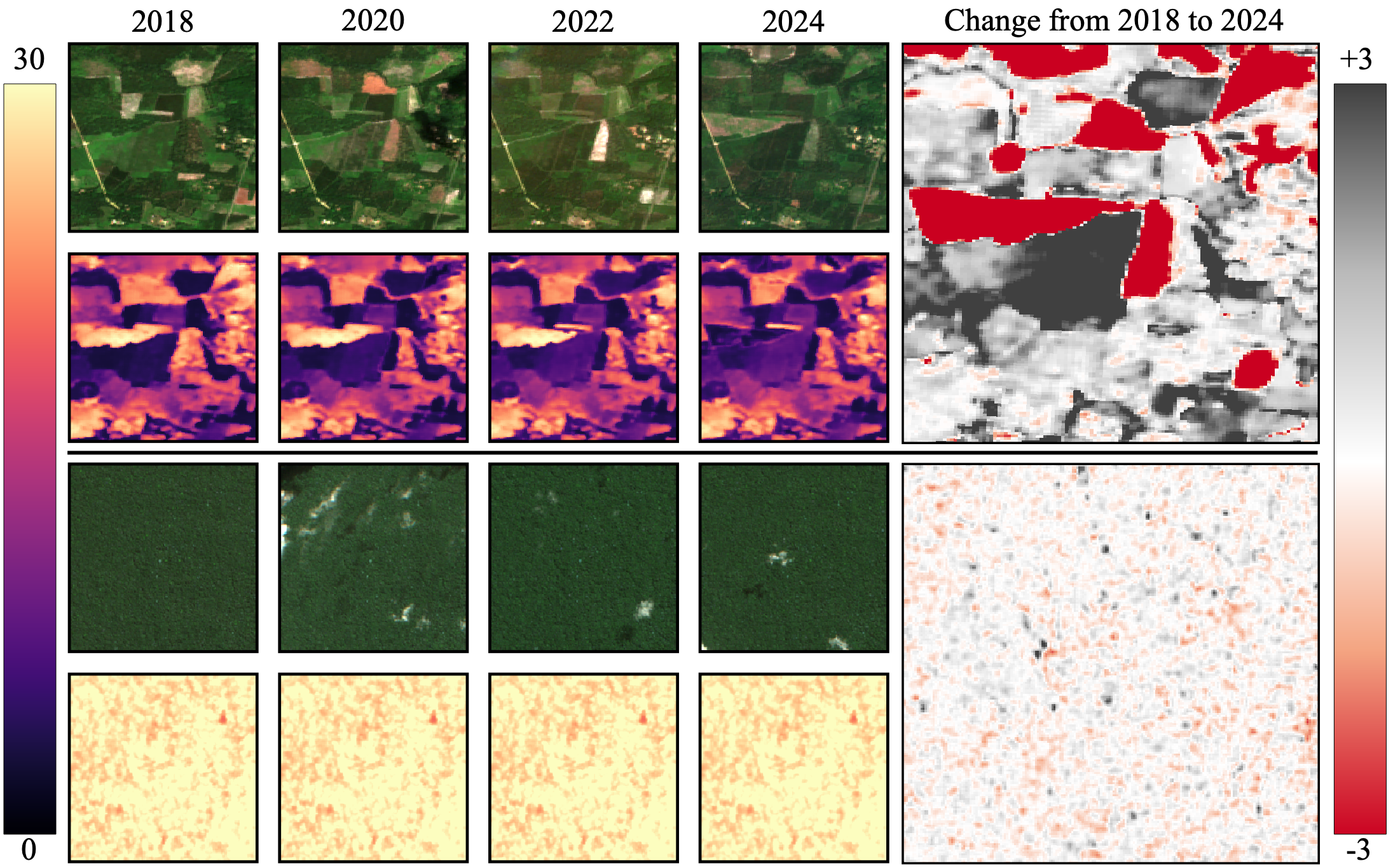
Forest monitoring is critical for climate change mitigation. However, existing global tree height maps provide only static snapshots and do not capture temporal forest dynamics, which are essential for accurate carbon accounting. We introduce ECHOSAT, a global and temporally consistent tree height map at 10 m resolution spanning multiple years. To this end, we resort to multi-sensor satellite data to train a specialized vision transformer model, which performs pixel-level temporal regression. A self-supervised growth loss regularizes the predictions to follow growth curves that are in line with natural tree development, including gradual height increases over time, but also abrupt declines due to forest loss events such as fires. Our experimental evaluation shows that our model improves state-of-the-art accuracies in the context of single-year predictions. We also provide the first global-scale height map that accurately quantifies tree growth and disturbances over time. We expect ECHOSAT to advance global efforts in carbon monitoring and disturbance assessment. The maps can be accessed at github.com/ai4forest/echosat.
@misc{pauls2026echosatestimatingcanopyheight, title = {ECHOSAT: Estimating Canopy Height Over Space And Time}, author = {Pauls, Jan and Schroedter, Karsten and Ligensa, Sven and Schwartz, Martin and Turan, Berkant and Zimmer, Max and Saatchi, Sassan and Pokutta, Sebastian and Ciais, Philippe and Gieseke, Fabian}, year = {2026}, eprint = {2602.21421}, archiveprefix = {arXiv}, primaryclass = {cs.CV}, tags = {ml,application,rs}, booktitle = {arXiv}, url = {https://arxiv.org/abs/2602.21421}, } - AISTATS
 Karsten Schroedter, Jan Pauls, and Fabian GiesekeIn Twenty-Ninth Annual Conference on Artificial Intelligence and Statistics (AISTATS), 2026
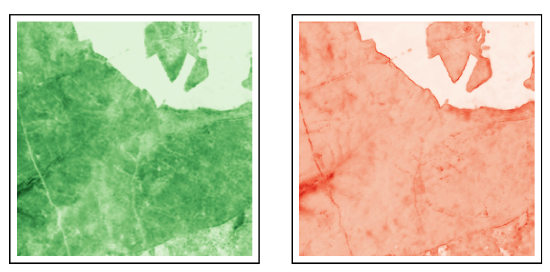
Accurate tree height estimation is vital for ecological monitoring and biomass assessment. We apply quantile regression to existing tree height estimation models based on satellite data to incorporate uncertainty quantification. Most current approaches on tree height estimation rely on point predictions, which limits their applicability in risk-sensitive scenarios. In this work, we show that with minor modifications to the prediction head, existing models can be adapted to provide statistically calibrated uncertainty estimates via quantile regression. Furthermore, we demonstrate how our results correlate with known challenges in remote sensing (e.g., terrain complexity, vegetation heterogeneity), indicating that the model is less confident in more challenging conditions.
@inproceedings{schroedter2026uncertaintytree, title = {Canopy Tree Height Estimation using Quantile Regression: Modeling and Evaluating Uncertainty in Remote Sensing}, author = {Schroedter, Karsten and Pauls, Jan and Gieseke, Fabian}, booktitle = {Twenty-Ninth Annual Conference on Artificial Intelligence and Statistics (AISTATS)}, year = {2026}, tags = {ml,application,rs}, projects = {ai4forest}, url = {https://openreview.net/forum?id=3foK47Zc9y}, } - JAG
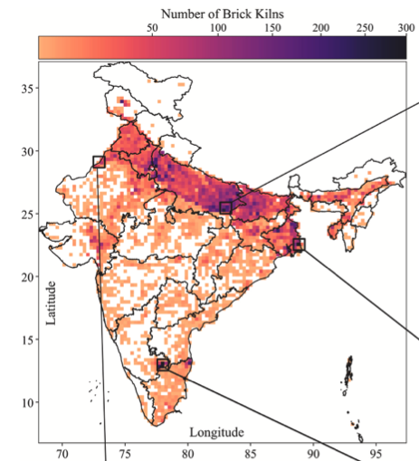 Sugandha Arora, Clement Goldmann, Stefan Oehmcke, and 7 more authors Jan Pauls, Chuanlong Zhou, Kushal Tibrewal, Abhinav Sharma, Harish C Phuleria, Fabian Gieseke, Philippe Ciais minimizeInternational Journal of Applied Earth Observation and Geoinformation, 2026
@article{arora2026brick, title = {Brick Kilns Across India: A Temporal Analysis of Brick Kiln Distribution and Technology Types}, author = {Arora, Sugandha and Goldmann, Clement and Oehmcke, Stefan and Pauls, Jan and Zhou, Chuanlong and Tibrewal, Kushal and Sharma, Abhinav and Phuleria, Harish C and Gieseke, Fabian and Ciais, Philippe}, journal = {International Journal of Applied Earth Observation and Geoinformation}, volume = {153}, pages = {105496}, publisher = {Elsevier}, year = {2026}, doi = {10.1016/j.jag.2026.105496}, url = {https://doi.org/10.1016/j.jag.2026.105496}, }
2025
- ICMLJan Pauls, Max Zimmer, Berkant Turan, and 4 more authors Sassan Saatchi, Philippe Ciais, Sebastian Pokutta, Fabian Gieseke minimizeIn ICML25: Proceedings of the 42nd International Conference on Machine Learning, 2025
With the rise in global greenhouse gas emissions, accurate large-scale tree canopy height maps are essential for understanding forest structure, estimating above-ground biomass, and monitoring ecological disruptions. To this end, we present a novel approach to generate large-scale, high-resolution canopy height maps over time. Our model accurately predicts canopy height over multiple years given Sentinel-1 composite and Sentinel 2 time series satellite data. Using GEDI LiDAR data as the ground truth for training the model, we present the first 10m resolution temporal canopy height map of the European continent for the period 2019-2022. As part of this product, we also offer a detailed canopy height map for 2020, providing more precise estimates than previous studies. Our pipeline and the resulting temporal height map are publicly available, enabling comprehensive large-scale monitoring of forests and, hence, facilitating future research and ecological analyses.
@inproceedings{pauls2025capturing, url = {https://arxiv.org/abs/2501.19328}, title = {Capturing Temporal Dynamics in Large-Scale Canopy Tree Height Estimation}, author = {Pauls, Jan and Zimmer, Max and Turan, Berkant and Saatchi, Sassan and Ciais, Philippe and Pokutta, Sebastian and Gieseke, Fabian}, booktitle = {ICML25: Proceedings of the 42nd International Conference on Machine Learning}, year = {2025}, } - RMSE
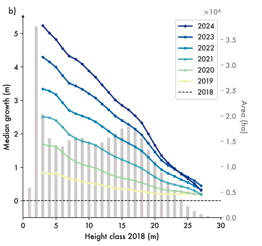 Martin Schwartz, Philippe Ciais, Ewan Sean, and 9 more authors Aurélien De Truchis, Cédric Vega, Nikola Besic, Ibrahim Fayad, Jean-Pierre Wigneron, Sarah Brood, Agnès Pelissier-Tanon, Jan Pauls, others minimizeRemote Sensing of Environment, 2025
High-resolution mapping of forest attributes is crucial for ecosystem monitoring and carbon budget assessments. Recent advancements have leveraged satellite imagery and deep learning algorithms to generate high-resolution forest height maps. While these maps provide valuable snapshots of forest conditions, they lack the temporal resolution to estimate forest-related carbon fluxes or track annual changes. Few studies have produced annual forest height, volume, or biomass change maps validated at the forest stand level. To address this limitation, we developed a deep learning framework, coupling data from Sentinel-1 (S1), Sentinel-2 (S2) and from the Global Ecosystem Dynamics Investigation (GEDI) mission, to generate a time series of forest height, growing stock volume, and aboveground biomass at 10 to 30-m spatial resolution that we refer to as FORMS-T (FORest Multiple Satellite Time series). Unlike previous studies, we train our model on individual S2 scenes, rather than on growing season composites, to account for acquisition variability and improve generalization across years. We produced these maps for France over seven years (2018–2024) for height at 10 m resolution and further converted them to 30 m maps of growing stock volume and aboveground biomass using leaf type-specific allometric equations. Evaluation against the French National Forest Inventory (NFI) showed an average mean absolute error of 3.07 m for height (r2 = 0.68) across all years, 86 m3 ha-1 for volume and 65.1 Mg ha-1 for biomass. We further evaluated FORMS-T capacity to capture growth on a site where two successive airborne laser scanning (ALS) campaigns were available, showing a good agreement with ALS data when aggregating at coarser spatial resolution (r2 = 0.60, MAE = 0.27 m for the 2020–2022 growth of trees between 10 and 15 m in 5 km pixels). Additionally, we compared our results to the NFI-based wood volume production at regional level and obtained a good agreement with a MAE of 1.45 m3 ha-1 yr-1 and r2 of 0.59. We then leveraged our height change maps to derive species-specific growth curves and compared them to ground-based measurements, highlighting distinct growth dynamics and regional variations in forest management practices. Further development of such maps could contribute to the assessment of forest-related carbon stocks and fluxes, contributing to the formulation of a comprehensive carbon budget at the country scale, and supporting global efforts to mitigate climate change.
@article{schwartz2025retrieving, url = {https://www.sciencedirect.com/science/article/pii/S0034425725003633}, title = {Retrieving yearly forest growth from satellite data: A deep learning based approach}, author = {Schwartz, Martin and Ciais, Philippe and Sean, Ewan and De Truchis, Aur{\'e}lien and Vega, C{\'e}dric and Besic, Nikola and Fayad, Ibrahim and Wigneron, Jean-Pierre and Brood, Sarah and Pelissier-Tanon, Agn{\`e}s and Pauls, Jan and others}, journal = {Remote Sensing of Environment}, volume = {330}, publisher = {Elsevier}, pages = {114959}, year = {2025}, } - SSRN
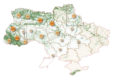 Integrating Global Canopy Height Models with Satellite Data for Improved Forest Inventory in UkrainePetr Lukeš, Viktor Myroniuk, Andrii Shamrai, and 3 more authors Viktor Melnichenko, Martin Schwartz, Jan Pauls minimizeAvailable at SSRN 5495040, 2025
Accurate forest monitoring in Ukraine faces unprecedented challenges due to ongoing Russian aggression and limited access to traditional inventory methods, requiring robust satellite-based alternatives for National Forest Inventory operations. This study develops a comprehensive framework integrating state-of-the-art canopy height models with harmonized multi-sensor satellite data to achieve airborne LiDAR-comparable accuracy in forest structural parameter estimation. We evaluated six CHMs against 2,634 in-situ canopy height measurements across Ukraine. The most recent European-scale CHM by Pauls et al.(2025) demonstrated superior performance with R2= 0.68 and RMSE= 4.65 m. Using this CHM as input alongside harmonized optical (Sentinel-2) and radar (Sentinel-1, ALOS PALSAR) observations, we developed a machine learning framework testing 20 algorithms to address whether satellite-derived canopy height enhances forest structural parameter estimation and whether country-trained models match regionally specific approaches. Feature importance analysis revealed CHM-derived height as the dominant predictor (45-60%), followed by Sentinel-2 shortwave infrared bands and vegetation indices. This approach achieved relative RMSE values of 8.8-12.3% across four forest structural parameters: growing stock volume (R2= 0.77), basal area (R2= 0.68), stand age (R2= 0.53), and diameter at breast height (R2= 0.48). Performance improvements of 49-144% were observed compared to models without height information, matching operational airborne LiDAR accuracy in Finland and USA. The framework successfully generates wall-to-wall forest inventory maps with robust transferability across diverse forest conditions. This research establishes satellite-based forest inventory as a viable alternative for conflict-affected regions and data-scarce environments worldwide.
@article{lukevs5495040integrating,
  url = {https://papers.ssrn.com/sol3/papers.cfm?abstract_id=5495040},
  title = {Integrating Global Canopy Height Models with Satellite Data for Improved Forest Inventory in Ukraine},
  author = {Luke{\v{s}}, Petr and Myroniuk, Viktor and Shamrai, Andrii and Melnichenko, Viktor and Schwartz, Martin and Pauls, Jan},
  journal = {Available at SSRN 5495040},
  year = {2025},
}

2024
- ICML
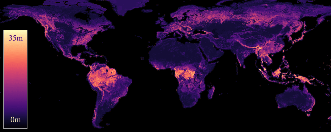 Jan Pauls, Max Zimmer, Una M Kelly, and 6 more authors Martin Schwartz, Sassan Saatchi, Philippe Ciais, Sebastian Pokutta, Martin Brandt, Fabian Gieseke minimizeIn ICML24: Proceedings of the 41st International Conference on Machine Learning, 2024
We propose a framework for global-scale canopy height estimation based on satellite data. Our model leverages advanced data preprocessing techniques, resorts to a novel loss function designed to counter geolocation inaccuracies inherent in the ground-truth height measurements, and employs data from the Shuttle Radar Topography Mission to effectively filter out erroneous labels in mountainous regions, enhancing the reliability of our predictions in those areas. A comparison between predictions and ground-truth labels yields an MAE / RMSE of 2.43 / 4.73 (meters) overall and 4.45 / 6.72 (meters) for trees taller than five meters, which depicts a substantial improvement compared to existing global-scale maps. The resulting height map as well as the underlying framework will facilitate and enhance ecological analyses at a global scale, including, but not limited to, large-scale forest and biomass monitoring.
@inproceedings{pauls2024estimating,
  url = {https://arxiv.org/abs/2406.01076},
  title = {Estimating Canopy Height at Scale},
  author = {Pauls, Jan and Zimmer, Max and Kelly, Una M and Schwartz, Martin and Saatchi, Sassan and Ciais, Philippe and Pokutta, Sebastian and Brandt, Martin and Gieseke, Fabian},
  booktitle = {ICML24: Proceedings of the 41st International Conference on Machine Learning},
  year = {2024},
}